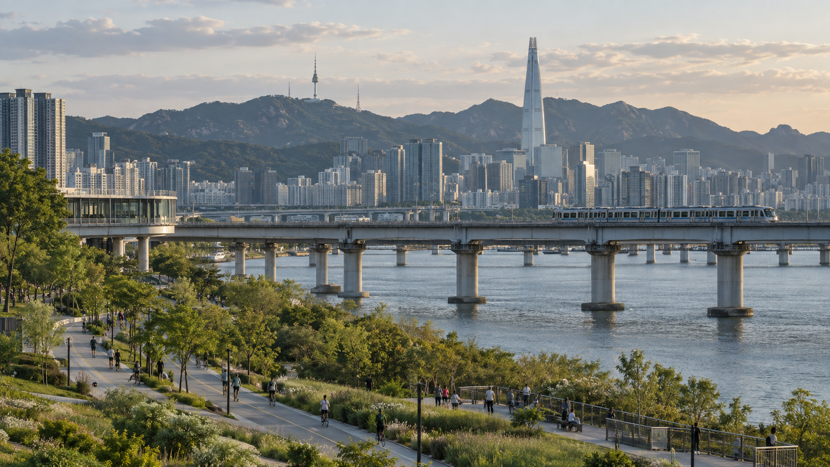
Seoul combines nature and high-tech urban life by concentrating dense housing, transit and digital services around a landscape shaped by mountains, the Han River and restored streams. Nature did not simply survive outside the city: geography constrained Seoul’s growth, while public projects connected parks, trails, waterways and transit to everyday life.
How does geography shape Seoul?
Wooded mountains rise inside and around the city, channeling development into valleys and along the river. Dense neighborhoods can therefore sit unusually close to trail networks and viewpoints. The Han River divides the metropolis while bridges and transit lines bind its districts together.
Why does Seoul feel both dense and green?
High-density development leaves sharp boundaries between built-up districts and steep terrain. Apartment towers, offices and stations may stand within minutes of riverside parks or mountain entrances. This is not untouched wilderness; it is a managed urban landscape supported by reforestation, trail maintenance and park investment.
How did public projects reconnect nature and city life?
Projects such as the restoration of Cheonggyecheon replaced road infrastructure with a public stream corridor. Riverside parks, neighborhood greenways and mountain trails now form a network of recreational spaces connected by public transportation.
What makes Seoul a high-tech city?
Digital payment, real-time transit information, fast communications and extensive public data make city systems easier to navigate. Seoul also uses spatial data and smart-city tools for planning and services. The important point is not technology for its own sake, but how it lowers the friction of moving through a very large city.
Is the balance perfect?
No. Heat, flooding, air pollution, habitat pressure and unequal access remain serious concerns. Popular trails and river parks require constant maintenance, while redevelopment can reduce local green space even as the city promotes larger flagship projects.
Three everyday journeys show how the systems overlap
From an apartment district to a trailhead. A resident can sometimes take the subway or a local bus to the foot of a mountain rather than planning a trip outside the city. The convenience comes from three different investments meeting in one place: dense transit demand, maintained public trails and accessible information about how to reach them. A navigation app helps, but it cannot replace the bus route or the physical path. Read why Korean mountains are accessible for the environmental and public-management history behind that experience.
From a station to the river. Seoul’s Han River parks may feel like an escape from urban density, but their usefulness depends on bridges, pedestrian connections, bicycle access and nearby neighborhoods. An attractive park that requires a difficult road crossing is not equally accessible to everyone. Thinking in terms of the entire journey—not simply the amount of green space—reveals why urban design matters.
From a crowded street to a coordinated trip. Digital arrival information, transit cards and mapping applications make an already complex network more legible. That convenience is partly a product of governance: separate vehicles and operators have to share compatible fare and information systems. The technology is visible, but cooperation among agencies is the less visible achievement. See how Seoul’s transport network became integrated.
Where the green-and-digital image breaks down
Neither green mountains nor digital services guarantee equal access. A trail with steep stairs can be difficult for someone with limited mobility; a river park may be nearby on a map but far away by a safe walking route. Real-time information can make transport easier to navigate while a long journey remains long. Seoul’s striking overlap of nature and technology is therefore best understood as an ongoing infrastructure project, with benefits that differ by neighborhood, age and ability—not as a city in which every inconvenience has been solved.
Cheonggyecheon: a stream brought back from under the road
The clearest example of Seoul changing its relationship with nature is Cheonggyecheon. The stream in the heart of the city was covered with concrete between the late 1950s and 1970s, and an elevated expressway was built above it, which for a time symbolised the city’s modernisation. After the city government decided to restore it, work ran from July 2003 to the autumn of 2005, with the stream reopening on October 1, 2005. According to the Cheonggyecheon Museum, the restoration covered about 5.84 kilometres of the stream.
The Encyclopedia of Korean Culture records that the elevated highway was demolished in 2003, that the project cost roughly 380 billion won, and that around 6.27 million people visited in the first month after opening. That response shows a strong public appetite for green space in the middle of a dense city. It also shows how a transport decision, removing a road, can be an environmental and urban design decision at once.
Mountains inside the city limits
Seoul’s mountains are part of everyday life, not an excursion. Bukhansan National Park is described by the city’s tourism office as the only national park in the Seoul metropolitan area, and the Korea National Park Service data reported by Aju Press put visits at about 7.53 million in 2025, the highest of any national park in Korea. The wooded appearance of these slopes also reflects national reforestation: Korea.net reports that about 63% of Korea’s land is now forest, after widespread degradation in the mid-twentieth century.
The lesson is that Seoul’s green space is mostly managed, not accidental. It exists because planners, forestry agencies and city governments chose to restore, protect and connect it.
FAQ
Are mountains really inside Seoul?
Yes. Several prominent mountains and extensive trails lie within the city boundary and are reachable by public transportation.
Is Seoul a green city?
Seoul has abundant mountains, river parks and restored waterways, but environmental quality varies by district and season.
Why is Seoul so technologically convenient?
Dense demand, long-term infrastructure investment and coordinated digital services make real-time information and cashless systems widely useful.
The mountain and the megacity
Seoul’s distinctive character comes from overlap rather than separation. Nature constrains the city, the city manages nature and technology helps residents move between both.
Sources and further reading
- Seoul Metropolitan Government: Green Trails Everywhere
- Seoul’s roadmap to expand urban green spaces
- Seoul Metropolitan Government: Spatial Data
- Cheonggyecheon Museum: About the restoration
- Encyclopedia of Korean Culture: Cheonggyecheon Restoration Project (in Korean)
- Korea.net: Reforestation creates green miracle
- Aju Press: Mt. Bukhansan most visited national park (Feb 2026)
2 thoughts on “How Seoul Combines Nature and High-Tech Urban Life”